1.0 BACKGROUND
Dredging at
Rackhams Cay continued, except for a break for repairs to pipes on Saturday 15th
until June 17th and another break to carry our dredging at Beacon
Shoal on June 19th. This allowed an examination of the reef to
determine the condition of the reef restoration site and corals on the windward
side of the reef nearest to the dredge cut line. The screen at Rackhams Cay was
also examined.
Water quality
sampling occurred on June 18th and dives were done at Rackhams Cay
on June 17th and June 20th. A monitoring flight was made on June 21st
.
2.0
DIVES
Dives carried out by TEMN concentrated on setting out sediment traps to monitor the impact of dredging plumes on the reefs that may have been affected by dredging and especially at the Rackham restoration site.
The examination dive carried out by NEPA on Wednesday 19th confirmed that there was little impact on the coral restoration area to date, and corals on the eastern (windward) side of Rackham Cay, north of the restoration, showed signs of stress, but were coping with the impact of the plume. Dredging is expected to continue until June 25. The activity so far did not appear to cause a major negative impact on the coral beyond the dredge site. However, it is recommended that a “clean-up” operation be carried out when dredging ceases to help speed the restoration of the site to its former condition.
3.0 AERIAL
MONITORING
Aerial photographs taken on June 21st show the silt screen being undercut by deep, tidal driven currents. However the dives revealed that corals appeared to be coping. Photos attached show the extent of the plume generated by dredging.
4.0 WATER
QUALITY MONITIORING
This report is based primarily on fieldwork carried
out on
METHODOLOGY
Field Work
Eight sites were identified for the monitoring
exercise as follows:
·
KTP 1
- Dredge Site (Bow of the Da Vinci –
Landward/Port Side)
·
KTP 2
- Dump Site (Just West of the Pipeline)
·
KTP 3
– Dump Side (Further West)
·
KTP 4
– East of the Dump Site
·
KTP 5
- Bow of the Da Vinci (Seaward/Starboard Side)
·
KTP 6
– Rackham’s Cay (At Screen – Landward Side)
·
KTP 7
– Rackham’s Cay (At Screen – Reef Side)
·
KTP 8
– Rackham’s Cay (Along South East Border)
Deep water sampling was carried out from tug boat
DN50 while the reef sites were sampled from a fisherman’s canoe. All sites were
assigned a GPS location except for Stations 7 and 8 (Table 1 and Figure 1).
Table 1: Dredging And
Reclamation In
Water Quality Sampling
Sites –
|
STATION NO |
DESCRIPTION |
|
|
|
KTP 1 |
Bow of the Da Vinci (Towards Land) |
17o 56.733' |
76o 50.985' |
|
KTP 2 |
Dump Site - W. Side of Pipe |
17o 55.428' |
76o 51.405' |
|
KTP 3 |
Western Edge of Dump Site |
17o 55.612' |
75o 51.650' |
|
KTP 4 |
East of Dump Site |
17o 55.331' |
76o 51.356' |
|
KTP 5 |
Bow of Da Vinci
(Towards Reef) |
17o 56.733' |
76o 50.985' |
|
KTP 6 |
Rackham Cay At Screen
(Landward side) |
17o 55.572' |
76o 50.605' |
|
KTP 7 |
Rackham Cay At Screen
(Reef side) |
|
|
|
KTP 8 |
R. Cay Along S. E.
Border - Restoration Site |
|
|
Sub-surface samples were collected using a Van Dorn
type sampler. Samples were designated T (surface), M (middle depth) and B
(bottom depth). Sampling was carried out between 1127 and 1310 hours.
Sample Analysis
Samples from were analysed by the Mines & Geology
Division laboratory in accordance with Standard Methods for the Analysis of
Water and Waste Water to determine TSS and turbidity.
TSS was determined by filtration of a known sample
volume through a dried, pre weighed filter. After filtration, the filter was
dried and re-weighed. TSS in mg/l is obtained through a determination of the
weight difference of the filter before and after filtration.
Turbidity was performed using the colorimetric method
and reported in FAU (formazin attenuated units). FAU incorporates a correction
for colour and thus gives a more realistic determination of turbidity.
OBSERVATIONS AND RESULTS
General Observations
The screens at Rackhams Cay appeared to be intact and
maintained their positions.
Sampling was carried out during sunny conditions. Sea
state was choppy and winds easterly. During this sampling exercise the Leonardo
Da Vinci was engaged in dredging. The dredge was positioned with the bow facing
east, and the pipe extending towards the west. The dredge and pipe formed a
semi-enclosed area with the north boundary of Rackham Cay.
There was a noticeable plume in the vicinity of the
dredge. The plume appeared more concentrated in the semi-enclosure. Spread of
the plume appeared more concentrated to the north-east and north-west. There seemed
to be less migration of material to the south.
At the West Middle Shoal dump site the plume was
observed to extend mainly westward and eastward but becoming diffuse about 200m
west of the pipeline. East of the pipeline the plume ceased to be visible long
before arriving at the screen protecting the Shoal (See attached Photographs).
Laboratory Results
Laboratory results are presented in Table 2, and
graphically in Figure 2. The results indicate a TSS range of 2 – 298mg/l for
all the stations monitored. The NEPA proposed Coral Reef Standard for suspended
solids is 10mg/l.
Table 2:
Dredge Monitoring -TSS at Rackham's Cay/Dump Site
|
STATION NO |
TIME |
DEPTH (M) |
LAB. RESULTS |
|
|
T (FAU)* |
TSS (mg/l) |
|||
|
1T |
1127 |
|
35 |
39.0 |
|
1M |
|
8.0 |
74 |
36.0 |
|
1B |
|
17.0 |
97 |
110.0 |
|
2T |
1151 |
|
<14 |
8.5 |
|
2M |
|
8.0 |
<14 |
17.0 |
|
2B |
|
15.0 |
509 |
298.0 |
|
3T |
1211 |
|
<14 |
20.0 |
|
3M |
|
7.0 |
<14 |
2.0 |
|
3B |
|
13.0 |
260 |
128.0 |
|
4T |
1232 |
|
<14 |
17.0 |
|
4M |
|
7.0 |
14 |
29.0 |
|
4B |
|
13.0 |
17 |
10.0 |
|
5T |
1255 |
|
353 |
255.0 |
|
6T |
1257 |
|
<14 |
17.0 |
|
7T |
1300 |
|
<14 |
9.5 |
|
8T |
1303 |
|
<14 |
16.5 |
|
8Ta |
|
|
<14 |
23.0 |
|
T
- Surface sample |
||||
|
B
- Depth sample |
||||
|
M
– Middle sample |
||||
|
(a)
- duplicate sample |
||||
The highest values were determined for samples taken
at the dredge site, and the dump site. The highest value was obtained for the
dump site bottom sample (KTP 2B). At the bow of the dredge on the reef side,
TSS was 255mg/l. On the landward side of the bow of the dredge (KTP 1B), TSS
was 110mg/l in the bottom sample.
At the bow of the dredge on the landward side (KTP
1), TSS at the surface was 39mg/l at the surface, and 36mg/l at middle depth.
At the dump site about 10m west of the pipe KTP 2),
TSS was 8.5mg/l at the surface, 17mg/l at middle depth, and 298mg/l at the bottom.
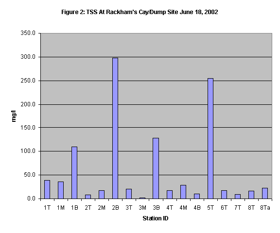
Around 100m west of the dumpsite (KTP 3) TSS was
determined to be 20mg/l at the surface, 2mg/l at middle depth, and 128mg/l at
the bottom.
About 30m east of the pipe at the dumpsite (KTP 4), TSS was 17mg/l at the surface, 29mg/l
at middle depth, and 10mg/l at the bottom.
At the screen just east of Rackhams Cay on the
landward side (KTP 6) TSS was 17mg/l while on the reef side (KTP 7) it was
determined to be 9.5mg/l. Duplicate samples taken along the south east border
of Rackhams Cay in the vicinity of the restoration area (KTP 8T and 8Ta) had
values of 16.5mg/l and 23mg/l.
CONCLUSION/ENVIRONMENTAL
IMPACT
·
Sea
conditions appeared to favour material remaining in suspension and spreading
mainly in a north east to a northwest direction.
·
The
silt screens appear to be withstanding the rough seas
·
At
the eastern silt screen at Rackham Cay the plume appeared to be no different on
both sides of the screen.
·
The
silt screen to the west of West Middle Shoal seemed to be in a position that is
not visibly subject to much TSS load.
·
Material
from the dredging appeared to pose visible threat to water quality at the
restoration site
·
Material
being deposited at West Middle Shoal appeared to pose no visible threat to the
Rackhams Cay restoration area.
| Home |