1.0 BACKGROUND
The dredging
Programme was suspended by NEPA on Friday 4th May and resumed on 11th
May. This was due to problems of
excessive sedimentation beyond the weir at R1.
Dredging resumed when separate licences were subsequently granted for
various aspects of the program. The
licence for continuation of activities at R1 was withheld pending advice to
NEPA the National Works Agency on the hydraulics of the Jew Gully outfall.
In keeping
with increased intensity of monitoring operations, as required by NEPA, water
quality sampling fieldwork was carried out on May 13th and 17th
2002.
Sampling scheduled for Monday May 27th had to be postponed
due to inclement weather as flood rains affected the island.
The sampling
exercise carried out on May 13th
was intended to provide measurement of
TSS (total suspended solids)/turbidity in the vicinity of the bund being established in the
R2.reclamation
area, west of Gordon Cay On May 17th,
sampling was done at the temporary disposal site at two stations to investigate
how effective the screen is in minimizing the amount of suspended solids
reaching the reef. However, high
currents tore sections of the northern part of the screen. Therefore, sampling was confined to southern
section of the screen which was secure.
Monitoring flights took place on May 13th and 28th and a selection of the photographs taken is attached.
Inspections of the silt screen at West Middle shoal took place on May 17, shortly after it was installed. The sea was very rough and the installation of the screen proved to be quite challenging for the divers. As mentioned above, the northern end of the screen was torn shortly after installation. Efforts were made to patch the screen when currents subsided. Another dive to inspect the screen, scheduled for the 26th May, was postponed due to inclement weather.
2.0 WATER
QUALITY MONITIORING
The objectives
were:
May 13: To obtain data on TSS (total
suspended solids)/turbidity in the vicinity of the bund being established in R2
just south east of the causeway.
May 17: To obtain measurements of TSS/Turbidity in the vicinity of west middle
shoal during dredging.
Field Work
On both occasions sites were established for the
collection of water samples and field measurements at multiple depths.
Sub-surface samples were taken using a Model No. 12.25 Eijkelkamp peristaltic pump
provided by Jan De Nul, as well as a Van Dorn water sampler. Samples were denoted T (surface), M (middle
depth), and B (bottom depth). Sampling was carried out between 1020 and 1208
hours.
May 13
Six sites were monitored, five of them starting in the
vicinity of the screen at R2 and heading south toward the channel (these were
identified as KTP 1-5 (Figure 1). A sample was also taken in the shallow area
just offshore the bund. All sites were assigned a GPS location (Table 1).
Table 1: Dredging And
Reclamation In
Water Quality Sampling
Sites -
|
STATION NO |
DESCRIPTION |
|
|
|
1 |
Just Outside Screen at
R2 |
18o 00.214' |
76o 46.196' |
|
2 |
South of Screen |
17o 58.617' |
76o 50.344' |
|
3 |
South of 2 |
17o 58.562' |
76o 50.278' |
|
4 |
South of 3 |
17o 58.422' |
76o 50.153' |
|
5 |
Channel |
17o 58.166' |
76o 49.857' |
May
17
Four sets of samples were collected at two sites – at
the dredge site west of West Middle Shoal, and outside the southern section of the
screen protecting the shoal. (Figure 2).
Shallow depth prevented the collection of samples inside the screen.
Table 2: Dredging And Reclamation In
Water Quality Sampling
Sites –
|
STATION NO |
DESCRIPTION |
|
|
|
1 |
Dredge
Site - West Middle Shoal |
17o 55.415' |
76o 51.216' |
|
2 |
At
Screen (outside) |
17o 55.376' |
76o 51.000' |
|
3 |
Dredge
Site - Resampled |
17o 55.450' |
76o 51.288' |
|
4 |
At
Screen - Resampled |
17o 55.343' |
76o 51.017' |
Sample Analysis
Samples were analysed by the Geological Survey
Division laboratory. Samples were analysed to determine TSS and turbidity. Analyses were conducted in accordance with
Standard Methods for the Analysis of Water and Waste Water.
TSS was determined by filtration of a known sample
volume through a dried, pre- weighed filter. After filtration, the filter was
dried and re-weighed. TSS in mg/l is obtained through a determination of the
weight difference of the filter before and after filtration.
Turbidity was performed using the colorimetric method
and reported in FAU (formazin attenuated units). FAU includes a correction for
colour and is approximately equivalent to TSS mg/l.
Observation
and Results
May 13, 2002
During this sampling exercise heavy-duty equipment
was observed assisting in the establishment of the bund at R2. Though progress
was obvious, there was significant slippage of material as well as the
emergence of small mud waves which created a shallow area extending about 15 M
southward from the bund (Appendix - Plate
1). The silt screen was in place though
it appeared to be overwhelmed by the choppy seas (Appendix - Plate 2). The
screen extended from the southern
Results of laboratory and field analyses are
presented in Table 3 along with sampling depth and time of sample
collection.
Table 3: Dredge Monitoring - R2
Bund near Causeway –
|
STATION NO |
TIME |
DEPTH (M) |
LAB. RESULTS |
FIELD DATA* |
|
|
T (FAU)* |
TSS (mg/l) |
TSS (mg/l) |
|||
|
1T |
1020 |
|
21 |
12.00 |
50 |
|
1Ta |
|
|
28 |
17.00 |
|
|
1M |
|
2.0 |
31 |
20.00 |
200 |
|
1Ma |
|
|
28 |
18.00 |
|
|
1B |
|
4.0 |
2835 |
2117.00 |
200 |
|
1Ba |
|
|
4933 |
23420.00 |
|
|
2T |
1117 |
|
18 |
12.00 |
50 |
|
2Ta |
|
|
27 |
25.00 |
|
|
2B |
|
4.0 |
23 |
14.00 |
50 |
|
2Ba |
|
|
30 |
41.00 |
|
|
3T |
1125 |
|
19 |
2.00 |
50 |
|
3Ta |
|
|
20 |
3.00 |
|
|
3B |
|
5.0 |
<14 |
4.00 |
350 |
|
3Ba |
|
|
38 |
32.00 |
|
|
4T |
1200 |
|
<14 |
2 |
50 |
|
4B |
|
6 |
<14 |
24 |
50 |
|
5T |
1210 |
|
<14 |
<1 |
50 |
|
5B |
|
7.0 |
<14 |
13.00 |
50 |
|
KTP R2 Bund |
|
0.5 |
82 |
55.00 |
|
|
T
- Surface sample |
|||||
|
B
- Depth sample |
|||||
|
(a)
- duplicate/replicate samples |
|||||
|
TSS
mg/l - Total Suspended Solids |
|||||
|
T
(FAU) - Turbidity in Formazin Attenuated Units |
|||||
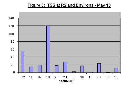
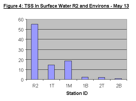
Laboratory results indicate TSS values ranging from
<1 - 23,420 mg/l (Figure 3). The highest values, 2117 and 23420mg/l were
reported for the bottom samples taken in the vicinity of the screen (KTP 1B,
and KTP1Ba respectively). All other samples analysed had a TSS range of <1 –
55mg/l. The highest value in this range was determined for the sample collected
at the bund (behind the screen) where depth was around 1M. For samples taken
just outside the screen, TSS was determined to be around 15mg/l in surface
water. In general TSS in surface water decreased steadily moving from the Bund
(R2) towards the channel (Figure 4).
![]()
![]()
During the sampling exercise, seas were
choppy to rough. Damage to the northern section of the screen was observed.
Results of laboratory analyses as well as
field measurements are presented in Table 4. Laboratory analyses indicated a range of
<1 – 81mg/l TSS for all samples. The
range determined from field measurements was 13 - 150mg/l.
Table 4: Dredge Monitoring – West Middle Shoal – May 17, 2002
|
STATION NO |
TIME |
DEPTH SAMPLED (M) |
LAB. RESULTS |
FIELD DATA* |
|
|
|
T (FAU) |
TSS (mg/l) |
TSS (mg/l) |
|
|||
|
1T |
1235 |
|
<14 |
2.0 |
50 |
|
|
1M |
|
8.5 |
22 |
81.0 |
50 |
|
|
1B |
|
17.0 |
<14 |
15.0 |
150 |
|
|
2T |
1302 |
|
<14 |
<1.0 |
13 |
|
|
2M |
|
8.5 |
<14 |
7.0 |
13 |
|
|
2B |
|
17.0 |
<14 |
21.0 |
13 |
|
|
3T |
1329 |
|
<14 |
8.0 |
20 |
|
|
3M |
|
8.5 |
<14 |
<1.0 |
20 |
|
|
3B |
|
17.0 |
<14 |
8.5 |
20 |
|
|
4T |
1342 |
|
<14 |
3.0 |
20 |
|
|
4M |
|
8.5 |
<14 |
<1.0 |
20 |
|
|
4B |
|
17.0 |
<14 |
<1.0 |
20 |
|
|
|
|
|||||
|
T
- Surface sample |
|
|||||
|
M
- Middle Depth
|
|
|||||
|
B
- Depth sample |
|
|||||
The highest values were determined for the
dredge plume (KTP 1) where TSS was determined by lab analysis to be 2mg/l for
the surface sample, 81mg/l at middle depth, and 15mg/l in the bottom sample.
Analysis of samples taken next at West Middle Shoal (KTP 2) indicated TSS of
<1mg/l at the surface, 7mg/l at middle depth, and 21mg/l at the bottom.
Re-sampling of the dredge site (KTP 3) 30 minutes later, (after the dredge had gone
to the 100m dump site), indicated TSS of 8mg/l at the surface, <1mg/l at
middle depth, and 8.5mg/l at bottom depth.
Re-sampling of West Middle Shoal (KTP 4), indicated TSS of 3mg/l at the
surface, and <1mg/l below the surface.
Conclusion/Environmental
Impact
May 13
·
Elevated
TSS levels were associated with the formation of the bund at R2. These levels appeared to be confined to the
immediate vicinity of the bund.
·
Slippage
of softer material from the bund formed a shallow area in which the floor is composed of very soft
material that is readily re-suspended. This
is a main contributor to the high TSS level determined in subsurface waters just outside the screen.
·
Settling
of most of the sediment appeard to take place within approximately 100m of the bund.
·
The
screen appeared to be helping to promote settling of sediment but it was easily damaged by windy conditions.
May 17
·
Dredging
appeared to have a negligible impact on TSS at West Middle Shoal at the time of sampling.
·
The
silt screen was easily torn by rough conditions.
Recommendations/Mitigation
·
Strategies
for reducing slippage of the bund should be investigated.
·
Silt
screens require close monitoring and should be repaired as required.
3.0 MONITORING
BY AIR
R2 Bund
The aerial examination of the R2 bund on May 13th showed no cause for alarm (Plates 3,4,5). The small mud waves were not visible from the air. The photograph of the Leonardo Da Vinci (Plate 6) showed some plume development although the plume spread was noted at approximately 200 metres from the dredge, in very shallow water.
North of R1
A helicopter flight was made
on May 27 to document the effects of heavy rainfall in the area for several
days. Unfortunately, poor visibility hampered efforts and affected the quality
of the photographs (Plates 7, 8). The area north of R1 was deluged with water
and the Jew Gully appeared to be flowing normally. An extensive plume was noted
coming from the Rio Cobre and from Sandy Gully, which emerged from the causeway
and caused considerable discolouration along the western side of the harbour.
4.0
RACKHAMS CAY
Dredging at the “temporary site” West of West Middle Shoal by the Christofforo Columbo began on Friday 17th May, and was monitored by our water quality team (See section 2.0). The dredging was carried out to remove the mud from the site (to the 1000m offshore dump site) in preparation for the deposition of clean material from Rackham Cay. This dredging was completed on Tuesday 28th May.
Dredging at Rackhams Cay was scheduled to begin on May 26th. This was delayed due bad weather that affected the groundwork for the exercise. The preparation of screens at Rackham and the laying of the pipeline to the temporary site were delayed. Attempts to lay the pipe on May 30th led to a break in the pipe that had to be repaired. Further, the screen at West Middle Shoal was again damaged due to rough seas. The estimated time for dredging to commence in this area is now June 6th or 7th. An inspection of the screen at Rackham carried out by TEMN on the 28th May showed it to be properly located and undamaged.
| Home |