| Home |
MONITORING REPORT
Technological and Environmental Management Network Ltd
DREDGING AND RECLAMATION PROGRAMME IN
The R1 bund preparation continued during the period covered by this report. First sector completed, material dredged from PB dredge site was still being pumped into the completed section of R1 from the Leonardo Da Vinci. Significant plume noted from the outlet weir in R1. Screen around outlet appears to be holding.(See Photographs)
The Christoforo Colombo dredged in the H1 and H2 areas at the following times:
The Christoforo was in the channel again between Wed. 20th and Friday 22nd February, bur the exact times were not available in time to be included in this report.
Monitoring flights
were carried out on February 11th and February 19th.
A water quality
monitoring exercise was carried out on
February 18th
The flight of
February 11th suggested that the screen at R3 was not very effective
at the time of the flight, however the “plume” noted in the attached photograph was in fact material on or near to the sea floor as the depth in the occluded area
was generally less than 0.6 m. There is some drift of the plume toward the SW
which will be further monitored. Water quality results for samples collected in
this area on February 18th are discussed later in this report.
Laboratory analysis results for the set of samples collected in December is now
available, and the data is reviewed in this report.
WATER QUALITY
MONITORING
1. December 13, 2001
This is a follow up of data presented in Monitoring report #3 dated
Methodology:
Monitoring of activities by sea. Water samples collected and field measurements made. Photographs taken.
Results:
Results of laboratory analysis are represented
in Figure 1 and Table 1. TSS data were discussed in Report No. 3. [4]
|
Table 1: Dredging and Reclamation in Water
Quality Sampling Sites - |
|||||||
|
Station ID |
LOCATION |
GPS N |
GPS W |
BOD |
TURB |
TSS |
COD |
|
1T |
Offshore |
17o58.925 |
76o50.542 |
2 |
3 |
77.9 |
405.6 |
|
1B |
|
|
|
2 |
3 |
114.7 |
351.0 |
|
2T |
Near Causeway
Brdge |
17o58.684 |
76o50.786 |
2 |
1 |
71.8 |
473.3 |
|
2B |
|
|
|
2 |
22 |
116.5 |
467.0 |
|
3T |
Dredge Site |
17o58.026 |
76o50.408 |
2 |
48 |
242.0 |
677.2 |
|
3B |
|
|
|
2 |
0 |
94.4 |
720.9 |
|
4T |
East of Dredge |
17o58.026 |
76o50.158 |
2 |
1 |
435.7 |
452.4 |
|
4B |
|
|
|
2 |
0 |
111.0 |
520.9 |
Biological Oxygen Demand (BOD), was <2 at all stations. COD was determined to be in the range 351 – 721 for all samples. The highest values were determined for the sample from the dredge site 3T and 3B, where COD was 677 and 721 respectively. Turbidity was determined to be in the range 0 – 48 NTU for all samples. The highest value for th s parameter (128 NTU) was determined for station 3 in the dredge plume where TSS was determined to be 93.6 mg/l. Other high values were determined for 3T, where turbidity was 48 NTU compared to a TSS of 242 mg/l, and 3B where turbidity was 22 NTU, while TSS was 116 mg/l. At 1T and 1B turbidity was 3 NTU but TSS was 78 and 115 respectively. At 4T (1NTU), and 4B (0 NTU), TSS was 436 and 111 respectively.
2.
This follows up on Monitoring
report #4 dated
|
Table 2: Dredging
And Reclamation In Kingston Harbour Water Quality Sampling Sites - January 16, 2002 |
|||
|
STATION NO |
DESCRIPTION |
N COORD. |
W COORD |
|
1T |
Plume in wake of
vessel that traversed Channel |
17o 58.216'
|
76o 49.590'
|
|
1M |
“ |
“ |
“ |
|
1B |
“ |
“ |
“ |
|
2T |
In Wake of Dredge
- H1 |
17o 56.638'
|
76o 51.299'
|
|
2M |
“ |
“ |
“ |
|
2B |
“ |
“ |
“ |
|
3T |
Bustamante Beacon |
17o 56.759'
|
76o 50.275'
|
|
3B |
“ |
“ |
“ |
|
4 |
H1 Resampled |
17o 56.695'
|
76o 51.303'
|
|
T - Denotes
Surface Sample B- Denotes Sample
collected near the bottom |
|||
Results:
Results of analyses of samples
collected on January 16th , as well as field data collected by Jan
De Nul on the same occasion are presented in Table 3.
Table 3: Lab results and field data of samples collected January 16, 2002
|
|
|
|
LAB. RESULTS |
FIELD DATA |
|
|
STATION NO |
TIME |
DEPTH (M) |
TURBIDITY (NTU) |
TSS (mg/l) |
TSS (mg/l) |
|
1T |
1215 |
|
47 |
448.20 |
50 |
|
1M |
|
|
2 |
95.50 |
100 |
|
1B |
|
13.00 |
18 |
147.30 |
180 |
|
2T |
1335 |
|
2 |
88.70 |
100 |
|
2M |
|
|
3 |
109.00 |
100 |
|
2B |
|
9.50 |
13 |
163.30 |
300 |
|
3T |
1352 |
|
2 |
78.50 |
5 |
|
3B |
|
4.50 |
3 |
232.30 |
5 |
|
4T |
1415 |
|
2 |
95.30 |
5 |
|
4M |
|
|
3 |
101.50 |
5 |
|
4B |
|
12.00 |
8 |
257.50 |
50 |
|
|
|
|
|
|
|
|
T - Denotes Surface Sample M – Denotes sample collected at mid depth B – Denotes Sample collected near the bottom |
|||||
TSS/Turbidity correlation for samples collected on this day, was particularly weak as indicated in Figure 2.
Figure 2: TSS vs. Turbidity – January 16, 2002
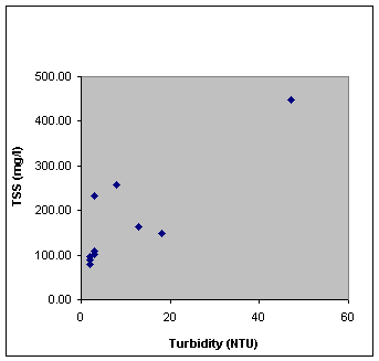
TSS in propeller plume of vessel was determined from field measurements to be in the range 0-180mg/l. The highest reading was recorded at the bottom of the water column, while the lowest reading was recorded at 6m below the surface. Laboratory analysis however had the value at 448 mg/l, the highest value found on this day. These results however are suspect and are being rechecked by the laboratory..
Please see report #4 dated 24th January 2001for an analysis of the field data collected.
3. January 24, 2002 & Jan 21 – Feb
3, 2002
The following data made available
by Jan De Nul is also reviewed:
·
Hunts Bay Turbidity Profiles - January
24, 2002
·
Turbidity from the fixed monitors at
Middle Ground, Angel, and Bustamante beacons for the period January 21 to
February 3, 2002
The attached map (Figure 3) identifies
both the fixed sites operated by Jan de Nul.
Hunts Bay Turbidity Profiles January 24, 2002 [2]
Data collected by Jan De Nul on
24/01/02 (Table 1) indicated a range of
TSS at four sites in Hunts Bay of 20 to 500 mg/l. The highest levels were found
closest to the berm (Sites 1, and 2). At site 1 the range was from 50 mg/l at the surface to 500 mg/l near the bottom while at
site 2 a level of 50NTU at the surface, and 300NTU near the bottom was
indicated. At site 3 (centre of the lagoon) the range measured was 100 NTU in a
thin layer at the surface. Just below this the level was 20 mg/l throughout the water
column, increasing to 100 mg/l
near the bottom.
|
Table
4: Turbidity Monitoring in Hunts Bay 24/01/02 (Summary
of Field Measurements by Jan de Nul) |
||
|
Site ID |
Description |
TSS Range in NTU |
|
1 |
Just off shore berm
(approx 200m from Causeway bridge) |
50 – 500 |
|
2 |
Just off shore berm Near
Water Box |
50 – 300 |
|
3 |
Closer to centre of
lagoon |
20 – 100 |
|
4 |
Near Causeway Bridge |
20 – 50 |
Turbidity From The Fixed Monitors At Middle Ground, Angel, and Bustamante Beacons For The Period January 21, To February 3, 2002 [3]
The
trend continues where the turbidity values at all fixed monitor sites reduce
subsequent to cleaning. However at Middle Ground beacon even though there was
reduction in values after cleaning on January 22, TSS remained relatively high
(50 – 300 mg/l) up to
January 25, while turbidity remains low (0 – 20 mg/l) at Bustamante and Angel beacons for the
same period. After January 25, and up to the next cleaning on January 29,
readings increase, particularly at Bustamante (20 – 300 mg/l), and Middle
Ground (50 – 500 mg/l). At Angel beacon a temporary increase to around 80 mg/l
is recorded in the nighttime of January 26. The range returns to 50 g/l before
cleaning on January 29. After cleaning, all readings get lower. Middle Ground
remains at around 50 until a sharp increase to over 700 mg/l and upwards from
February 1 to 3. The pattern is similar in data from the monitors at Angel and
at Bustamante beacons, though less pronounced at the latter.
4. January 28, 2002
Methodology:
Samples were collected on January
28 for laboratory analysis and field measurements of TSS were also made at the
following sites( Table 5):
·
Dredge Plume east of Burial Ground
Beacon
·
Dredge Plume at Burial Ground Beacon
Samples were taken at three
depths denoted T (Surface), M (Mid way the water column), B (0.5m form the
bottom).
|
Table 5 : Dredging and Reclamation in Kingston Harbour Water Quality
Sampling Sites January 28, 2002
|
|||
|
STATION NO |
DESCRIPTION |
N COORD. |
W COORD |
|
1T |
Dredge Plume east
of Burial Ground |
17o 57.652'
|
76o 50.809' |
|
1TA |
“ |
“ |
“ |
|
1B |
“ |
“ |
“ |
|
1BA |
“ |
“ |
“ |
|
2T |
Dredge Plume at
Burial Ground |
17o 57.678'
|
76o 50.872' |
|
2B |
“ |
“ |
“ |
|
2BA |
“ |
“ |
“ |
|
T - Denotes
Surface Sample B- Denotes Sample
collected near the bottom |
|||
Results:
Results of analyses of samples
collected on January 28th , as well as field data collected by Jan
De Nul on the same occasion are presented in Table 6.
|
Table
6: Dredging and Reclamation in Kingston Harbour Water Quality Sampling Sites - January 28, 2002 |
|||||
|
|
LAB.
RESULTS |
FIELD DATA* |
|||
|
STATION
NO |
TIME |
DEPTH
(M) |
TURBIDITY
(NTU) |
TSS
(mg/l) |
TSS
(mg/l) |
|
1T |
1004 |
15 |
4 |
106.8 |
50 - 150 |
|
1TA |
|
|
4 |
99.9 |
|
|
1B |
|
|
22 |
183.3 |
150 - 250 |
|
1BA |
|
|
24 |
188.3 |
|
|
2T |
1020 |
14 |
6 |
100.7 |
100 - 200 |
|
2B |
|
|
33 |
227.4 |
|
|
2BA |
|
|
30 |
212.9 |
200 - 300 |
|
T - Denotes Surface
Sample B- Denotes Sample
collected near the bottom |
|||||
Field measurements (Table 6) indicate a range
of 50 – 300 mg/l for TSS in field profiles taken in the dredge plume in the
vicinity of Burial Ground beacon. In general the lower values were found near
the surface. The levels recorded here was in a similar range of TSS to that
determined by field measurement on Jan 16, which indicated a range of 100 – 300
mg/l (Table 7). The levels taken in the prop plume of a ZIM container vessel
are included for comparison.
|
Table 7: Comparison
of Prop Plume (PP) to Dredge Plume (DP) |
|||
|
PP JAN 16 |
DP JAN 16 |
DP1 JAN 28 |
DP2 JAN 28 |
|
0-180mg/l |
100 - 300 |
50 – 250 |
100 - 300 |
|
|
|
|
|
|
DP1 Dredge Plume - East
of Busatamante Beacon |
|||
|
DP2 Dredge Plume -
Busatamante Beacon |
|||
Conclusions/Environmental Impact:
·
TSS associated with the dredging
appears to be around twice that associated with propeller wake from typical
shipping traffic.
·
Sites closest to the berm in Hunts Bay
appear to be more affected by TSS. Away from the berm the problem is
considerably less. More intensive monitoring could be carried out to determine
if this increase is due to material shedding from the berm.
·
Though fouling of the sensors for the
fixed monitors is an obvious contributor the high readings, there it would
appear that impact at Middle Ground continues to be greater than at Angel, and
Bustamante beacons as was observed in the previous Monitoring Report.
·
The sediment forming the TSS does not
appear to have any measurable BOD though COD is high( See Fig 1) This is in
agreement with background values from the EIA, and is quite likely due to oil
residues which were determined to be present in sediment analysed for the EIA.
Follow Up:
·
More intensive monitoring of WQ in
hunts Bay near the berm
·
Aerial observation of plumes backed up
with ground truthing
·
Monitoring of dump sites R3 and R1
·
Monitoring of Rackhams Cay dredging
5. February 18th, 2002
Background:
The
sampling exercise carried out on February 18, was intended to provide
measurement of TSS (total suspended solids)/ turbidity in the vicinity of Hunts
Bay where filling was in progress. In addition it was hoped that correlation
between turbidity and TSS could be strengthened. Preliminary analytical results
from the laboratory indicate a weak correlation between TSS and Turbidity data
collected in December. Salt water interference was suspected.
Methodology:
Monitoring
on February 18 was carried out from a skiff “Viceroy HB” - skipper Vincent
Clarke, to enable observation of the silt screen near Fort Augusta, as well as
sampling in shallow areas. Four sites were sampled in the vicinity of Fort
Augusta (Figure 5), in order to assess the effectiveness of the silt screen.
Sampling was also carried out in the main fishing area in Hunts Bay to assess
the impact of filling activities in the Bay. These sites were identified as
Stations 1 – 6 (see Table 8).
|
Table 8: Dredging And Reclamation In
Kingston Harbour Water Quality Sampling Sites - February 18, 2002 |
|
|||||
|
STATION NO |
DESCRIPTION |
N COORD. |
W COORD |
|
|
|
1T |
At screen (on landward side) |
17o 58.105' |
76o 50.723' |
|
|
|
1TA |
Duplicate of 1T |
|
|
|
|
|
2T |
Just North East of Screen |
17o 58.129' |
76o 50.692' |
|
|
|
2TA |
Duplicate of 2T |
|
|
|
|
|
3T |
Further North East |
17o 58.132' |
76o 50.629' |
|
|
|
3TA |
Duplicate of 3T |
|
|
|
|
|
3B |
.5m from Bottom at Station 3 |
|
|
|
|
|
3BA |
Duplicate of 3B |
|
|
|
|
|
4T |
North East of Station 3 |
17o 58.161 |
76o 50.444 |
|
|
|
4TA |
Duplicate of 4B |
|
|
|
|
|
5T |
Angel Beacon |
17o 57.177' |
76o 49.546' |
|
|
|
5TA |
Duplicate of 5T |
|
|
|
|
|
6T |
Hunts Bay (Midway Between Rio Cobre
Mouth and Causeway) |
17o 58.673' |
76o 51.005' |
|
|
|
6TA |
Duplicate of 6T |
|
|
|
|
|
T - Denotes Surface Sample B - Denotes Sample collected near the
bottom |
|
||||
|
|
|||||
Samples
were collected in duplicate at all stations, and, with the exception of Station
3 where a bottom sample was taken sampling was at the surface. The sampling
exercise on February 18, was carried out between 1025 and 1140. It was observed
that there was some sediment in the pipe cock of the sampler while dispensing
the first of the duplicate samples taken at 3B. This sample visibly had more
sediment than the duplicate 3BA.
Samples
were analysed by Poly-Diagnostics Centre in accordance with Standard Methods
for the Analysis of Water and Waste Water. TSS was determined by filtration of
a known sample volume through a dried, pre weighed filter. After filtration,
the filter was dried and re-weighed. TSS in mg/l is obtained through a
determination of the weight difference of the filter before and after
filtration. As a precaution against salt water interference, filters were
rinsed with warm distilled water after filtration of the sample. This
precaution was employed in analysing the set of samples collected on February
18.
Results and
Observations:
At
the time of our visit, it was noted that the screen was in place, but had been
damaged. The damage was immediately reported to allow prompt repairing of the
screen. Damage to the screen was noted on the section closer to the Causeway (See Photographs). The section towards Fort
Augusta was observed to be intact (See Photographs).
Results
of analyses of samples collected on February 18, as well as field data
collected by Jan De Nul on the same occasion are presented in Table 9.
Table 9: Lab results and field data of samples collected Feb 18, 2002
|
|
LAB.
RESULTS |
FIELD
DATA* |
|||
|
STATION
NO |
TIME |
DEPTH
(M) |
TURBIDITY
(NTU) |
TSS
(mg/l) |
TSS
(mg/l) |
|
1T |
1025 |
<0.5 |
38 |
102.60 |
200-300 |
|
1TA |
|
|
36 |
96.60 |
|
|
2T |
1037 |
|
2 |
14.60 |
20-40 |
|
2TA |
|
|
3 |
11.40 |
|
|
3T |
1040 |
|
2 |
9.60 |
20-30 |
|
3TA |
|
|
2 |
11.20 |
|
|
3B |
|
1.5 |
53 |
184.30 |
30-40 |
|
3BA |
|
|
22 |
61.60 |
|
|
4T |
1056 |
1.5 |
2 |
10.00 |
10 |
|
4TA |
|
|
1 |
9.00 |
|
|
5T |
1116 |
3.0 |
1 |
3.40 |
5 |
|
5TA |
|
|
2 |
5.20 |
|
|
6T |
1138 |
4.0 |
2 |
7.20 |
10 |
|
6TA |
|
|
3 |
6.60 |
|
|
T - Denotes
Surface Sample |
|||||
|
B- Denotes
Sample collected near the bottom |
|||||
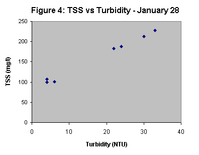
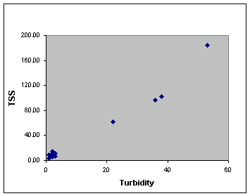
Turbidity at all stations monitored on February 18, was determined to be in the range 1 – 53 NTU. This corresponded to a TSS range of 3.4mg/l – 184.3 mg/l. With the exception of Station 3 bottom samples, there was good agreement between the duplicate samples taken. Field data by Jan De Nul indicated a range of 5 – 300mg/l for all stations. Correlation between TSS and Turbidity for February 18 was very good (Figure 6). compared to that observed for data collected on January 28 (Figure 4). TSS/Turbidity correlation for samples collected on January 16, was particularly weak (Figure 2).
Figure 6: Relationship between Turbidity and TSS values
from samples collected on Feb 18, 2002
For
samples collected on February 18, the highest value (184.3mg/l) was determined
for Station 3 in the first of the duplicates taken at the bottom (3B). the
other duplicate however had a value of 61.6mg/l. The corresponding value by Jan
De Nul was 30 – 40mg/l. The highest value in surface water (102.6 and 96.6mg/l)
was determined for samples from Station 1 (landward side of screen).
In general, TSS was lower on the seaward side of the screen with the exception of the sample taken at 3B (Figure 7). With the exception of the outlier value the range of TSS on the seaward side of the screen was 9.0 – 14.6mg/l. The lowest value was determined for the sample taken at the furthest point from the screen, while the highest value was determined for the sample taken just outside the screen. Values determined from field measurements carried out by Jan De Nul, were generally greater than values determined by laboratory analysis.
Figure 7: TSS and Turbidity values – Feb 18, 2002
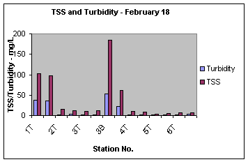
At Angel beacon, TSS was determined to be 3.4 and 5.2mg/l for the duplicate samples. Field measurement indicated a level of 5mg/l at this site. At station 6 (Hunts Bay), TSS was determined to be 7.2, and 6.6mg/l in duplicate samples.
Conclusion/Environmental
Impact:
Based
on sampling carried out on February 18, the following may be concluded with
regard to environmental impact:
·
The screens deployed in the vicinity of
Fort Augusta appeared to be having a mitigating effect on the release of
sediment to areas beyond R3. The relatively quiescent conditions in R3 would also
be expected to promote settling out of sediment. This would explain the
reduction in sediment that was observed north of R3 despite damage observed to
the screen.
·
At the time of sampling water quality
at Angel beacon showed no measurable impact that could be associated with
dredging activities. TSS level was well below the draft ambient standard of
10mg/l.
·
Water quality at the Hunts Bay site was
within the draft TSS standard.
·
The excellent correlation between TSS
and Turbidity suggests that determination of the latter is sufficient to
monitor impact of the dredging. Turbidity measurements can be more readily
determined and can be used to determine the criteria parameter TSS.
Recommendations/Follow
Up:
·
It is recommended that future
monitoring involve analysis to determine turbidity, so that TSS be derived from
the plot presented in this report (Figure 6).
·
The screens should be monitored closely
and repaired as needed.
REFERENCES
1. Results
of Monitoring Turbidity in Kingston Harbour on 28/01/01, Jan De Nul, 2/2/02.
2. Results
of Monitoring Turbidity in Hunts Bay Lagoon on 24/01/02, Jan De Nul, 24/01/02.
3. Turbidity
Graphs Weeks 4 and 5, Jan De Nul, 08/02/02.
4. Kingston Transhipment Port Expansion Monitoring Report No. 2, Date of Trip: December 13, 2001 TEMN and January 24, 2002.
| Home |