BACKGROUND:
Water quality
sampling fieldwork was carried out on
The sampling
exercise carried out on March 11, was intended to provide measurement of TSS
(total suspended solids)/turbidity in the channel (H1 and H2) where dredging
was in progress.
A monitoring flight took place on 18th March and a selection of the photographs taken are attached.
An inspection of the berm at R1 was carried out on March 13th. The R1 bund preparation continued during the period covered by this report. The first sector was completed and work continued in the extension of the berm by PIHL. Significant plume from this activity was noted in our monitoring flight of March 19. The screen around the berm preparation activity was down at the time of our flight and was being repaired.
METHODOLOGY:
Monitoring on
March 11 was carried out in the channel near
Table
1: Dredging And Reclamation In
Water Quality Sampling
Sites March 22, 2002
|
DESCRIPTION |
STATION NO. |
|
Wake of Heinrich (Surface) 18o 00.218' 76o 46.736' |
1 |
|
Dredge Plume North of Dredge 17o 57.417' 76o 50.999' |
2 |
|
Area recently dredged 17o 57.147' 76o 51.197' |
3 |
|
West of Delbert Sicard Beacon 17o 56.894' 76o 51.525' |
4 |
|
Station 3 Resampled 17o 57.150' 76o 51.201' |
5 |
|
Angel Beacon 17o 57.180' 76o 49.607' |
6 |
Samples were
generally collected at three depths (sub-stations) at each site sampled using
the Van Dorn sampler. These sub-stations were denoted T (surface sample), M
(middle depth), and B (bottom depth). The exception was station 6 - Angel
beacon where sampling was confined to the surface.
Samples were
analysed by Poly-Diagnostic Centre in accordance with Standard Methods for the
Analysis of Water and Waste Water. TSS was determined by filtration of a known
sample volume through a dried, pre weighed filter. After filtration, the filter
was dried and re-weighed. TSS in mg/l is obtained through a determination of
the weight difference of the filter before and after filtration. As a
precaution against salt-water interference, filters were rinsed with warm
distilled water after filtration of the sample. This precaution was employed in
analysing samples collected subsequent to February 18.
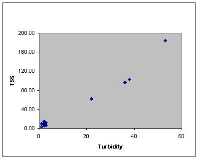
Relying on the
good correlation between turbidity and TSS determined from the February data
(Figure 2) the WQ team was able to collect more samples. Most of these samples
were analysed to determine turbidity. TSS was then determined from the plot of
TSS vs. turbidity (Figure 2). Turbidity
only was determined at Stations 1, 2, and 4, while as a control, turbidity and
TSS were measured at stations 3, 5, and 6.
Figure 2: TSS vs Turbidity – February 22nd
OBSERVATION
AND RESULTS
During the exercise, sea state was calm, with a light SW wind. There was no visible plume associated with a small container vessel traversing the channel. On approaching sector H1 a plume was observed just north of where the dredge was operating. There was a visible plume remaining after the departure of the dredge.
Laboratory and
field data are summarised in Table 2.
Laboratory
Results:
Laboratory analysis results indicate a range of TSS for all sites monitored of 3.6–76.1mg/l. The highest values were reported for the dredge site (Station 5) where TSS was determined to be 34.0mg/l at the surface, 43.1mg/l at middle depth, and 78.1mg/l at the bottom. At station 2 (fugitive plume) TSS was 12mg/l at the surface, 32.3mg/l at middle depth and 18.2mg/l at the bottom. In the wake of the small container vessel, TSS was 5.5mg/l at the surface, 3.6mg/l at middle depth, and 6.7mg/l at the bottom. At station 5 (dredge site after 30min) TSS was 7.6mg/l at the surface, 14.6mg/l at middle depth, and 69.2mg/l at the bottom. At station 6 TSS was 9.7mg/l at the surface. At station 4 (west of Sicard beacon) TSS was 13.5mg/l at the surface, and 7.8mg/l below the surface.
Table
2: Kingston March 11,
2002
|
STATION
NO |
TIME |
DEPTH
(M) |
LAB.
RESULTS |
FIELD
DATA* |
|
|
TURBIDITY
(NTU) |
TSS
(mg/l) |
TSS
(mg/l) |
|||
|
1T |
1030 |
0.5 |
|
5.5 |
15 |
|
1M |
|
6.5 |
|
3.6 |
5 |
|
1B |
|
13.0 |
|
6.7 |
20 |
|
2T |
1050 |
0.5 |
|
12.0 |
20 |
|
2M |
|
6.0 |
|
32.3 |
10 |
|
2B |
|
12.0 |
|
18.2 |
10 |
|
3T |
1057 |
0.5 |
6.0 |
34.0 |
50 |
|
3M |
|
6.0 |
7.0 |
43.1 |
100 |
|
3B |
|
12.5 |
19.0 |
78.1 |
300 |
|
4T |
1112 |
0.5 |
|
13.5 |
5 |
|
4M |
|
5.0 |
|
7.8 |
5 |
|
4B |
|
9.5 |
|
7.8 |
10 |
|
5T |
1129 |
0.5 |
1.0 |
7.6 |
20 |
|
5M |
|
6.0 |
3.0 |
14.6 |
10 |
|
5B |
|
12.5 |
15.0 |
69.2 |
150 |
|
6T |
1148 |
0.5 |
1.0 |
9.7 |
5 |
|
6M |
|
2.0 |
|
- |
10 |
|
6B |
|
4.0 |
|
- |
50 |
Field
Data
Field
data collected by Jan De Nul on March 11 indicated a range of 5 –
300mg/l for TSS at the sites monitored. The highest values were determined for
Station 3, the dredge site.
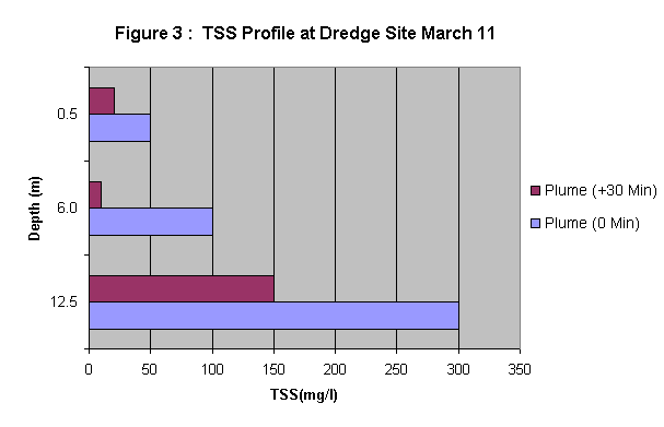
At the dredge
site TSS was 50mg/l at the surface, 100mg/l at middle depth (6.0M), and 300mg/l at the bottom (12.5M). At this same
site approximately thirty minutes later, the values were significantly reduced
to 20mg/l at the surface, 10mg/l at middle depth, and 150mg/l at the bottom
(Figure 3).
In the wake of the Heinrich, Station 2 TSS was
determined to be 15mg/l at the surface, 5mg/l at middle depth (6.5M), and
20mg/l at the bottom (13M).
![]()
![]() NRCA
Standard
NRCA
Standard
At Station 3 -
the plume north of the dredge site, TSS was determined to be 20mg/l at the
surface, and 10mg/l below the surface.
At Station 4
(west of Delbert Sicard beacon), TSS was determined to be 5mg/l at surface and
middle, and 10mg/l at the bottom.
At Angel
beacon (Station 6) TSS was 5mg/l at the surface, 10mg/l at middle depth (2.0M)
and 50mg/l at the bottom (4.0M).
Data from the fixed stations indicated a range of 20
– 200mg/l TSS at Middle ground. For March 4, TSS was around 50mg/l increasing
to 200mg/l prior to cleaning on March 5. Subsequent to cleaning TSS reading
dropped to around 20mg/l increasing to 160mg/l at around 1100 on March 7. TSS
remains high even after cleaning on March 8. After cleaning on March 9 however,
TSS drops to 20mg/l through March 10.
At Bustamante
beacon the range for TSS -was 5 – 40mg/l throughout March 4 to March 10.
CONCLUSION/ENVIRONMENTAL
IMPACT
Results
indicate that effects of the dredging were confined to the channel. The effect
was not noticeable at the sampling location to the west of the dredge site or
at Angel beacon.
The
significant fall off in TSS at the dredge site over a 30 minute period
indicates that the impact from dredging on water quality is significant for a
relatively short period. The fact that the bottom values are also significantly
higher than at the surface suggests that much of the disturbed material settled
rapidly.
Data from the fixed stations suggest that impact from TSS is greater at Middle Ground.
| Home |